Geography/GIS Section
Geography/GIS Section
GEOGRAPHY/GIS SECTION
The main objective of Geography/GIS Section of Support Services Wing is to prepare maps of census areas for Population & Housing Censuses and various other field surveys in the country for complete coverage of area and population. This Section includes eight state of the art GIS Labs (at Islamabad, Peshawar, Lahore, Multan, Karachi, Quetta, Muzaffarabad & Gilgit) equipped with modern technology (Workstations, Large scale Plotters/Scanners, Colour Printers, Cameras, GPS Devices, etc.) with about 100 experienced staff.
Activities of this Wing are detailed below:
Updating of Area List:
The Area Frame means the list of administrative units of various orders, for which the census results are tabulated and published in the Census Reports.
Pakistan is a federation and administratively divided into four federating provincial units – the Khyber Pakhtunkhwa, Punjab, Sindh and Balochistan provinces and Islamabad Capital Territory (ICT), Azad Jammu & Kashmir and Gilgit-Baltistan.
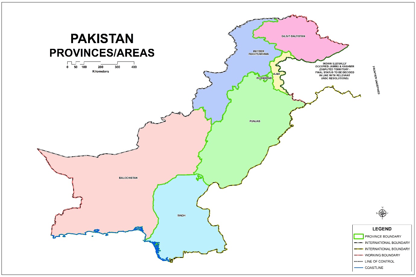
Provinces are divided into Divisions, Divisions into Districts, and Districts into Sub-Divisions that generally consist of one tehsil/taluka.
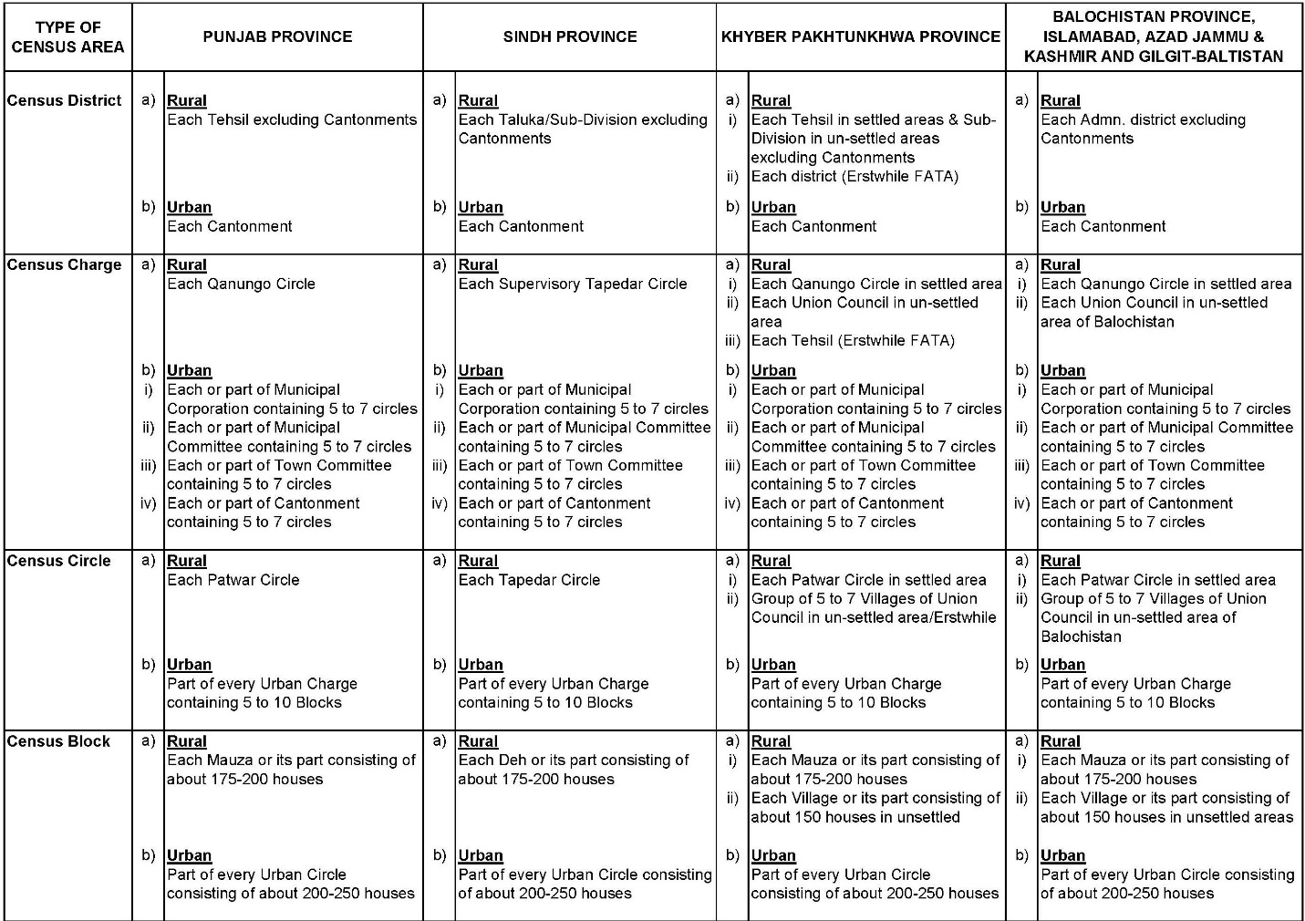
In rural part, lower order units are Qanungo/Supervisory Tapedar Circles (QCs/STCs), Patwar/Tapedar Circles/Union Councils (PCs/TCs/UCs) and Mauzas/Dehs/Villages.
In urban areas, the units below the Tehsils/Talukas are Metropolitan/Municipal Corporations, Municipal Committees, Town Committees and Cantonments.
Changes occur in the boundaries of administrative units during the intercensal period due to creation of new units or reconstitution of older ones.

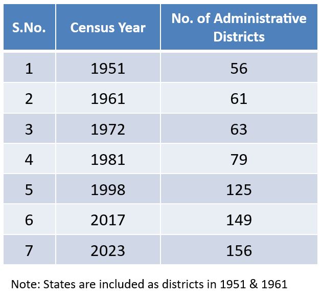
Since the census results are published for each of the above mentioned units, therefore, prior to the delimitation of census areas, the list of administrative units needs to be updated.
As a prerequisite to this exercise, boundaries of all administrative units were frozen before Census so that the list once prepared/updated is not changed till the census operation is over.
Area Lists have been got verified from the concerned Census District Officers before Census.
Maps are essential tool to ensure complete coverage and proper delimitation of Supervisory and Enumeration Areas.
PBS procured Mauza/urban area maps from relevant Boards of Revenue/Local Government Departments which were updated from time to time by PBS staff with the help of Revenue/Local Government staff.
Rural/Urban block boundaries were digitized and the same were used by Enumerators through tablets for the Digital Census – 2023.
Block maps with satellite imagery in the background were also provided to Enumerators for better understanding of their area.
Delimitation of Census Areas:
Many countries, including Pakistan, conduct Censuses of Population and Housing using census enumeration areas (EA) i.e. a Census Block.
The EA is defined as the workload of a census enumerator during the enumeration period. In addition, other census geographic areas do not cross administrative areas.
To ensure complete coverage of area & population and for effective field supervision, the whole country including Azad Jammu & Kashmir and Gilgit-Baltistan has been delimited on a four-tier system, into Census Districts, Census Charges, Census Circles and Census Blocks.
The delimitation work was supervised by the Deputy Commissioners in Balochistan province, Islamabad, Azad Jammu & Kashmir and Gilgit-Baltistan, while the work of delimitation had been supervised by the Assistant Commissioners in the provinces of Khyber Pakhtunkhwa, Punjab and Sindh and Cantonment Executive Officers in Cantonment areas, who are appointed as the Census District Officers.
Census blocks are delimitated on the basis of number of houses keeping in view the workload that an enumerator could complete within the target period.
Boundary of each block is kept on well identified geographic features like road, street, stream, river, canal, railway line, mala, path and pagdandi, etc. so that Enumerators could easily understand its boundaries.
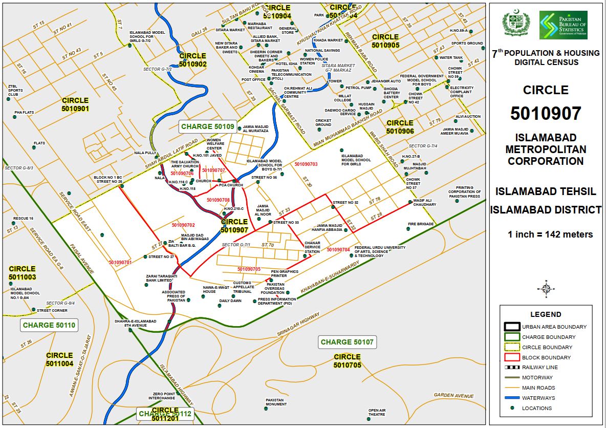
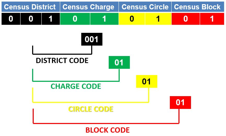
A unique nine digit geo-code has been assigned to each Census Block.
Of these, the first three digits starting from 001 have been assigned to the Census District.
A Census District has been divided into Charges and two digit codes from 01 have been assigned to each Charge (00101).
The Census Charges have further been divided into Census Circles and Circles are assigned two digit codes (0010101).
The last two digits have been given to the Census Blocks in each Circle completing code (nine digits code 001010101) for a Census Block.
Updation/Digitization of Rural/Urban Blocks:
Digitization of rural/urban blocks has been done at all GIS Labs of Pakistan Bureau of Statistics.
The bifurcation of big rural/urban blocks having more than 400 households reported in Census – 2017, PSLM & Labour Force surveys and survey of high rise buildings constructed after 2017 was completed before Census – 2023.
An exercise has also been done in all GIS Labs of PBS in which big blocks have been identified through Satellite images and bifurcated blocks were assigned geo-codes in Area Frame.
Final position of Urban and Rural Blocks after said exercises is given below:-
Activities | Total Blocks Census 2017 | New | Total Blocks Census 2023 |
| Rural Blocks: | 113388 | 5206 | 118594 |
| Updation of Rural Area Frame |
| 4673 |
|
| Bifurcation of Big Rural Blocks | 3408 | ||
| High Rise Buildings | 22 | ||
| Bifurcation through Satellite images | 1260 | ||
| Urban Blocks: | 55556 | 11339 | 66895 |
| Bifurcation of Big Urban Blocks |
| 4872 |
|
| Shifting of blocks from Rural | 4157 | ||
| High Rise Buildings | 386 | ||
| Bifurcation through Satellite images | 1924 | ||
Grand Total: | 168944 | 16545 | 185489 |
Number of Census Areas Census – 2023:
Province/Area | Number of Charges | Number of Circles | Number of Blocks | ||||||
Rural | Urban | Total | Rural | Urban | Total | Rural | Urban | Total | |
| Khyber Pakhtunkhwa | 331 | 79 | 410 | 2307 | 470 | 2777 | 24988 | 3885 | 28873 |
| Punjab | 807 | 798 | 1605 | 7436 | 4267 | 11703 | 59284 | 34462 | 93746 |
| Sindh | 273 | 657 | 930 | 1458 | 3682 | 5140 | 19561 | 24252 | 43813 |
| Balochistan | 226 | 79 | 305 | 567 | 288 | 855 | 9261 | 2596 | 11857 |
| Islamabad Capital Territory | 3 | 12 | 15 | 35 | 75 | 110 | 904 | 833 | 1737 |
| Azad Jammu & Kashmir | 70 | 32 | 102 | 378 | 90 | 468 | 3431 | 693 | 4124 |
| Gilgit-Baltistan | 33 | 5 | 38 | 132 | 21 | 153 | 1165 | 174 | 1339 |
Grand Total:- | 1743 | 1662 | 3405 | 12313 | 8893 | 21206 | 118594 | 66895 | 185489 |
The Role of GIS in Census:
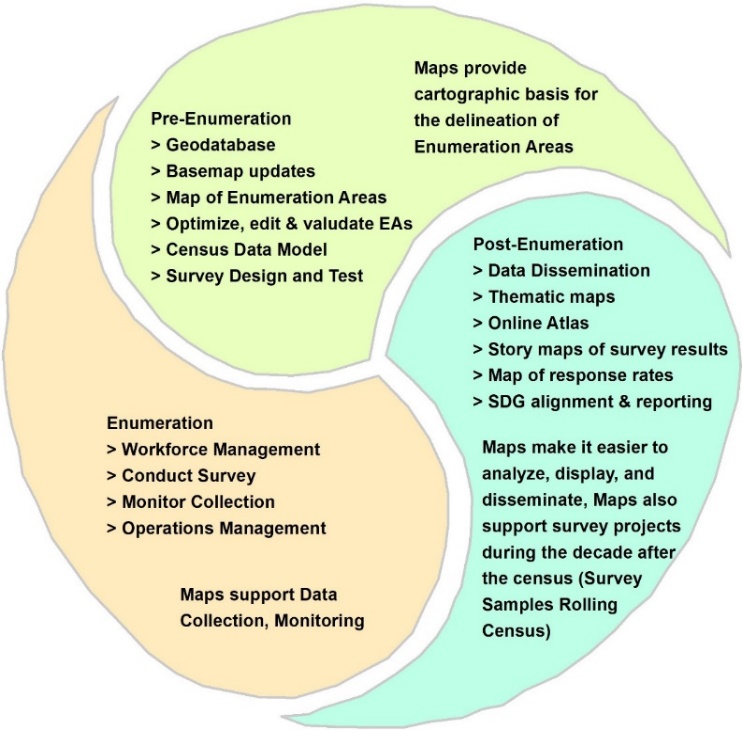
Mapping is widely recognized as one of the most crucial census activities, playing an important role in providing the geographic basis used during the actual process of enumeration.
Owing to recent technological developments in GIS and other geospatial technologies, the scope of census mapping has been extended to census data analysis and dissemination, with greater efficiency in data collection and enumeration.
Achievements:
Transformation of manual urban/rural maps into computer based/digital Enumeration Block maps using ESRI software ArcGIS for digitization work and latest satellite imagery for accuracy and better visualization of enumeration area.
Preparation of Block maps with satellite image background to facilitate Enumerators in identification of their assigned areas for successful conduct of Census – 2023.
Preparation of various layers using ArcGIS techniques for administrative and census boundaries (National, Provincial, Divisional, District, Tehsil, QH/STC, PC/TC, Mauza, Urban Area and Blocks).
Various layers like police jurisdiction, Union Council, Wards/Neighbourhood Councils have also been digitized on demand from various public departments.
Scanning of Mussavis/revenue record for accurate Mauza boundaries of Khyber Pakhtunkhwa and Punjab provinces.